
GNSS
The TCS GNSS Data and Products
(EPOS-GNSS) provides access to standardized and quality-checked GNSS data, metadata and products of thousands
of continuously operating GNSS stations (GNSS = Global Navigation Satellite Systems, e.g. GPS, GLONASS, Galileo,
Beidou) installed throughout Europe or European overseas areas.
These data can be used to precisely measure ground deformations that are human-induced or have a natural orgin e.g. volcanoes or earthquakes.
GNSS data and metadata from GNSS stations integrated in EPOS can be accessed in
a centralized way through the EPOS-GNSS Data Gateway,
while the resulting GNSS products (station position time series, velocities and
strain rate maps) can be accessed via the EPOS-GNSS Product Portal.
Both portals are connected to the EPOS Data Portal
that makes the GNSS (meta)data and products discoverable to the wider EPOS community.
EPOS-GNSS is built on the existing EUREF Permanent GNSS Network
(EPN) and a number of separate GNSS networks operated by National Research Infrastructures from across Europe.
The EPN is a network of about 400 permanently tracking GNSS stations installed at fixed locations all over Europe.
ROB (Royal Observatory of Belgium), who hosts the EPN Central Bureau,
manages the EPN in collaboration with several EPN coordinators.
ROB and EUREF have been working together for many years to
develop the EPN towards a GNSS network providing open access to standardized GNSS data, metadata, and products.
The Royal Observatory of Belgium is a major contributor to EPOS-GNSS through:
- The delivery of GNSS data as a data provider
- The provision of pan-European GNSS services
- Involvement in the governance and coordination of the EPOS ERIC and the consortium of the TCS "GNSS Data and Products"
1. GNSS data provider
Fig. 1. Belgian permanently tracking GNSS data whose data are integrated in EPOS.
Belgium is covered with one of the most dense GNSS networks in the world offering
huge potential for solid Earth research.
"To unlock this potential to EPOS users", ROB is operating a national EPOS-GNSS data node that provide access to the daily GNSS data from the following data providers (Fig. 1):
"To unlock this potential to EPOS users", ROB is operating a national EPOS-GNSS data node that provide access to the daily GNSS data from the following data providers (Fig. 1):
- ROB (ROB-GNSS network),
- Digitaal Vlaanderen (FLEPOS network),
- Service Public de Wallonie (WALCORS network),
- National Geographic Institute (GPSBru),
- Centre Spatial de Liège, Université de Liège,
- Geological Survey of Belgium, Belgian Institute of Natural Sciences.
Other Belgian operators of permanently tracking GNSS stations can contact epos-be@oma.be if they wish to integrate their GNSS station(s) in EPOS.
2. Pan-European GNSS Services
The pan-European services that ROB provides to EPOS-GNSS have been built on
ROB's EUREF services. With the support of BELSPO these services have been
upgraded to respond the needs of EPOS' workflows. Since 2022, EPOS ERIC is
financially contributing to the operation of part of these pan-European services:
a) Pan-European data node making the data of the EPN discoverable to EPOS
ROB is operating an EPOS-GNSS data node on top of its publicly
open data repository of the entire EPN GNSS data collection
provided on a voluntary basis by about 100 agencies distributed over Europe.
The ROB-EUREF data node makes the data of the EPN stations that agreed to share data with EPOS downloadable through the
EPOS Data Portal
and the EPOS-GNSS Data Gateway.
The data cover the period from 1996 until now (more than 2 million data files).
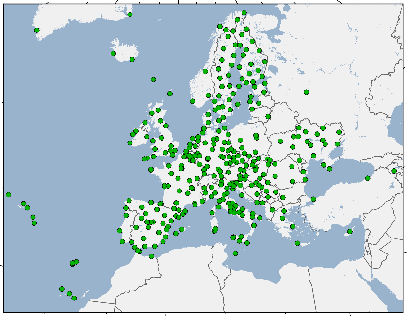 Fig. 2. EUREF's GNSS stations whose data are integrated in EPOS through the ROB-EUREF data node.
b) Ground deformation monitoring of the EPN stations
Every 15 weeks ROB computes the positions, velocities (Fig. 3 and 4), and position time series of the EPN stations in order to maintain the
European Terrestrial Reference System (ETRS89).
More details are provided on the web site of the EPN Central Bureau.
These products provide information on ground deformations especially valuable for geophysical research.
ROB's GNSS products are available from the
EPOS Data Portal
and the EPOS-GNSS Product Portal.
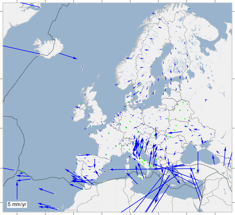 Fig. 3. Horizontal velocities of the EPN stations expressed in the ETRS89.
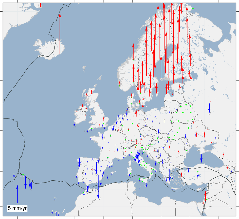 Fig. 4. Vertical velocities of the EPN stations expressed in the ETRS89.
c) GNSS station metadata management service (M3G)
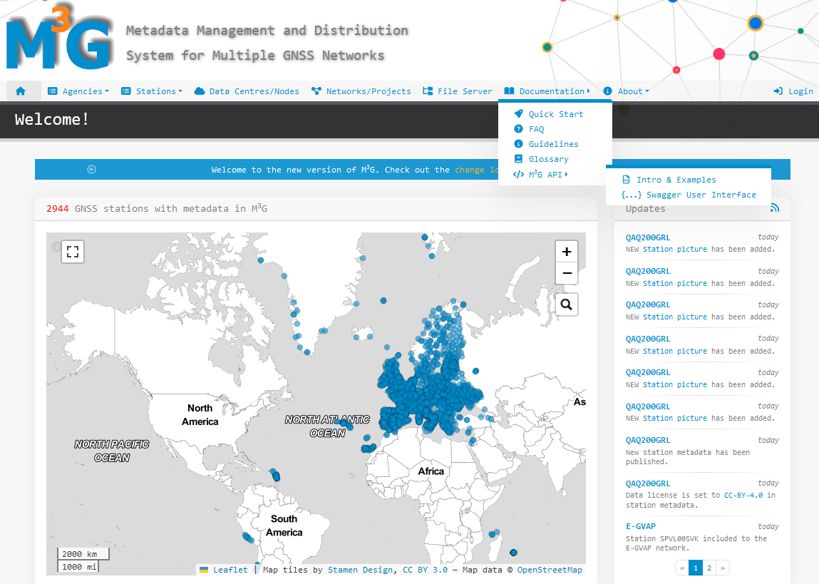 Fig. 5. M3G portal
M3G stands for "Metadata Management and Dissemination System for Multiple GNSS Networks" (Fig. 5).
EPOS' GNSS data providers must use M3G to upload, validate, and distribute their GNSS station metadata such as IGS-style site logs,
information about local networks, data owner, DOIs, data license, etc... M3G's primary goal is to collect rich metadata as recommended by the
FAIR data principles.
M3G is maintained by the ROB as a common service of EUREF and EPOS.
A selected part of the metadata gathered by M3G are available from the
EPOS Data Portal through the
EPOS-GNSS Data Gateway.
The full set of station metadata can be directly retrieved from the M3G
GUI or
API.
M3G is one of the Community Portals of the TCS "GNSS data and products".
d) EPOS-GNSS Data Quality Monitoring Service (DQMS)
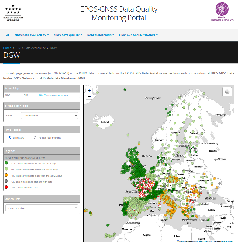 Fig. 6. DQMS portal
ROB's EPOS-GNSS Data Quality Monitoring Service monitors the availability and quality of the daily GNSS data that are made discoverable through the TCS "GNSS data and products".
The DQMS front-end public portal (Fig. 6)
provides maps and plots that are updated at least daily. The information provided by the portal is used e.g.,
as feedback to GNSS data suppliers or as input for the geophysical interpretation of the computed station positions and their evolution in time.
The DQMS portal is one of the Community Portals of the TCS "GNSS data and products".
Governance and coordination
ROB is one of the 10 members of the TCS "GNSS data and products" Consortium.
By doing so, ROB expressed its willingness to provide EPOS-GNSS services and be
a key agency in the governance of the GNSS TCS. Hence, ROB has a seat on the EPOS-GNSS Consortium Board.
In addition, as chair of the EPOS-GNSS Executive Board, ROB coordinates the
day-to-day EPOS-GNSS activities, the implementation of mechanisms for quality
checking the GNSS stations' metadata and data, the compliance check with the
EPOS data policy, the interface with EUREF, and it attracts new GNSS data
suppliers to join EPOS. This last activity is also aiming at consolidating the
sustainability of the overall EPOS infrastructure.
Until November 2022, ROB represented the GNSS TCS in the EPOS ERIC Service Coordination Committee
(SCC, Fig. 7). The SCC, representing all the EPOS TCS and the Integrated Core Services
Central hub (ICS-C), provides support and advice to the EPOS Executive Director
in formulating and executing the EPOS ERIC Annual Work Program. Since November
2022, ROB chairs the SCC and is a member of the EPOS ERIC Executive Committee.
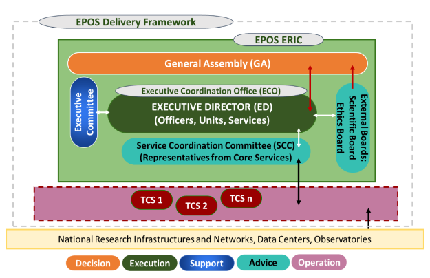 Fig. 7. EPOS-ERIC organizational structure